
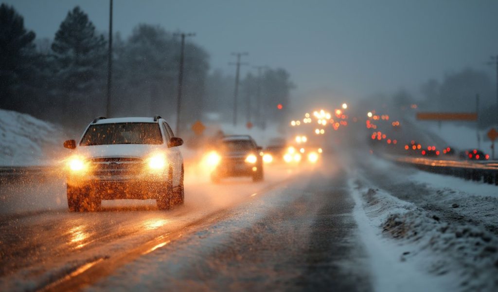
Snow tapered off across Minnesota during Wednesday morning’s commute, but blustery conditions and icy roads lingered throughout the day as families prepared for Thanksgiving travel. The winter storm that delivered several inches of accumulation to central and southern parts of the state finally moved out, though strong wind gusts topping 40 miles per hour continued to whip around loose snow and create challenging visibility. Road conditions improved slowly as crews worked to clear highways and side streets on one of the busiest travel days of the year, with many routes remaining partially or completely snow-covered well into the afternoon. The temperature reached just 29 degrees in the Twin Cities, falling eight degrees below the normal high of 37 for late November.
Harsh Commute Prompts School Closures Statewide
The combination of overnight snowfall and morning gusts created dangerous travel conditions that forced numerous school districts across Minnesota to cancel classes Wednesday. Parents scrambled to make childcare arrangements as administrators decided the risks of getting buses and students safely to school outweighed the benefits of holding classes the day before Thanksgiving break. The timing proved particularly challenging for families already planning holiday travel, as many had hoped to hit the road early Wednesday to avoid traffic. State patrol and local law enforcement responded to dozens of crashes and spinouts throughout the morning hours, though most incidents involved property damage rather than serious injuries, officials reported.
Thanksgiving Day Brings Quiet But Frigid Conditions
Minnesota residents can expect a quiet but exceptionally cold Thanksgiving Thursday, with partly sunny skies and a high of just 27 degrees in the Twin Cities paired with a low dropping to 15 degrees overnight. While winds will remain noticeable, gusts won’t reach the intensity seen Wednesday when sustained blasts made outdoor activities uncomfortable and windchills dangerously low. The calm weather pattern provides relief for anyone hosting outdoor gatherings or needing to transport dishes between locations, though the bitter cold means keeping beverages on the porch requires careful monitoring to prevent freezing. This marks one of the coldest Thanksgivings the region has experienced in recent years, with temperatures running roughly 10 degrees below average for late November.
Even Colder Air Moves In This Weekend
The cold snap intensifies as Minnesota heads into the final days of November and early December, with forecasters warning that temperatures will plunge further this weekend. Highs are expected to dip into the teens both Sunday and Monday, creating conditions more typical of mid-winter than the tail end of autumn. Meteorologists are also monitoring the potential for another round of snow Saturday or Sunday, though exact timing and accumulation amounts remain uncertain as models continue adjusting their predictions. The arctic air mass settling over the Upper Midwest shows little sign of retreating soon, suggesting Minnesota residents should prepare for an extended period of below-normal temperatures that could persist well into the first week of December.
Travel Conditions Gradually Improve After Storm
Despite the slow improvement in road conditions Wednesday, most major highways and interstates were passable by afternoon as Minnesota Department of Transportation crews worked around the clock to clear snow and apply treatment. The winter storm dropped between four and eight inches across central Minnesota, with lighter amounts to the north and south creating a patchwork of road conditions that required careful navigation. Travelers heading out for Thanksgiving were urged to check road conditions before departing, allow extra time for their journeys, and pack emergency supplies including blankets, food, water and phone chargers in case they encountered problems. Officials emphasized that while main routes were clearing, many secondary roads and rural highways remained snow-packed and slippery, particularly in areas where drifting created hazardous spots.
Pattern Shift Signals Extended Winter Weather
The dramatic change from Minnesota’s unusually mild autumn to harsh winter conditions signals a significant pattern shift meteorologists expect will persist through early December. After weeks of above-average temperatures that delayed the arrival of meaningful snowfall, the state has now plunged into a cold regime more characteristic of January than late November. This rapid transition caught some residents unprepared, as many had grown accustomed to the extended fall weather that allowed outdoor activities and delayed winterization projects. Weather experts note that such sharp swings are becoming more common as climate patterns evolve, creating challenges for everything from agriculture to infrastructure planning across the Upper Midwest region.


