
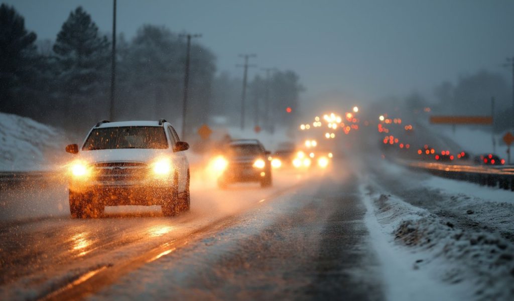
Minnesota residents should prepare for a sharp temperature drop Friday night following a morning snow system that created challenging conditions for commuters in the Twin Cities area. Temperatures across the state will plunge into the teens, with northern regions experiencing single-digit readings overnight [web:26]. Saturday will bring little relief, with high temperatures struggling to reach the teens and wind chill values dropping into single digits, making outdoor activities uncomfortable and potentially dangerous for those without proper winter clothing [web:26]. The cold snap represents the latest chapter in what has been a notably frigid December for Minnesota, with temperatures running below historical averages throughout the month [web:23].
Winter Weather Advisory Issued For Southern Counties
The National Weather Service has issued a winter weather advisory for southern Minnesota, effective from noon Saturday through midnight, as a snow system pushes into the region [web:26]. The snow will initially develop in southwestern Minnesota during the afternoon hours before tracking eastward across the southern portion of the state throughout the evening. This system will primarily impact areas along and south of Interstate 90, where travel conditions could deteriorate rapidly as snow accumulates on roadways. Residents in the advisory area should monitor weather updates closely and consider postponing non-essential travel during the heaviest snowfall periods. Motorists who must venture out should reduce speeds, increase following distances, and ensure their vehicles are equipped with emergency supplies including blankets, flashlights, and fully charged mobile phones.
Varied Accumulation Totals Expected Across The State
The Twin Cities metro area will see relatively modest snowfall from this system, with accumulations between 1 and 2 inches expected by Sunday morning [web:26]. However, southern Minnesota will bear the brunt of the storm, potentially receiving between 3 and 5 inches of snow, with some counties along the Iowa border possibly exceeding 6 inches [web:26]. These higher totals could create hazardous driving conditions and require significant snow removal efforts for residents and municipalities. The gradient in snowfall amounts reflects the track of the low-pressure system, which will keep the heaviest precipitation bands focused across the southernmost counties. Northern Minnesota will remain largely unaffected by this particular system, though the region will still contend with the bitterly cold temperatures gripping the entire state.
Extended Forecast Brings Continued Winter Challenges
Sunday will offer no respite from the cold, with high temperatures stuck in the low teens across most of Minnesota. The beginning of the work week will feature snow flurries on Monday, though temperatures will moderate slightly into the 20s, providing some relief from the weekend chill. Tuesday will see temperatures climb into the upper 20s, but a wintry mix of precipitation will develop and persist through Wednesday, potentially creating slippery conditions for multiple days. Commuters should remain vigilant and allow extra time for travel during this period as roads may become icy, especially on bridges, overpasses, and shaded areas where temperatures remain colder. The mixed precipitation could transition between snow, sleet, and freezing rain depending on slight temperature fluctuations.
Another Temperature Drop And Snow Chance Late Week
After the midweek wintry mix moves through, temperatures will drop again as the end of the work week approaches. Current forecasts indicate another chance for snow on Thursday, though specific details about timing and accumulation amounts remain uncertain this far in advance. The pattern suggests Minnesota will remain locked in an active winter weather regime with frequent systems bringing snow and cold temperatures through at least the middle of December. Residents should stay informed about changing weather conditions by checking forecasts regularly and signing up for weather alerts through local emergency management offices. Those with outdoor activities planned should have backup indoor options available and dress in layers when venturing outside, as wind chill values will make actual temperatures feel even colder than thermometer readings indicate throughout the extended forecast period.


